Introduction to Ngoa Long Mountain
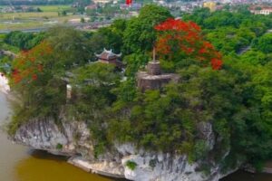
Ngoa Long Mountain, also known as Lying Dragon Mountain, is a limestone ridge located inside the Mua Cave (Hang Mua) complex in Ninh Binh. Rather than being a standalone attraction, Ngoa Long Mountain forms the natural backbone behind Mua Cave and is responsible for the iconic panoramic views overlooking Tam Coc.
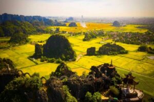
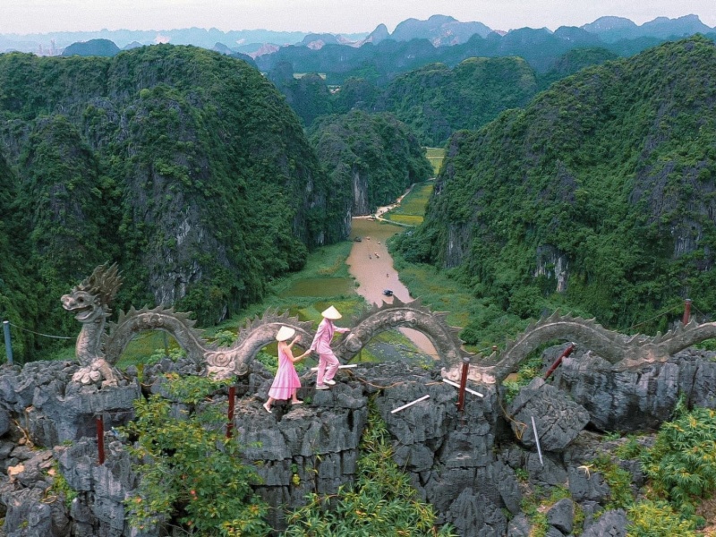
Seen from afar, the mountain resembles a giant dragon resting among rice fields and karst formations — with its head facing east and tail curving west. This unique shape has given rise to local legends and is one of the reasons the Mua Cave viewpoint is considered among the most beautiful in northern Vietnam.

Where Is Ngoa Long Mountain Located?
Ngoa Long Mountain is part of the Hang Mua tourist area, within the UNESCO-listed Trang An Landscape Complex. It is located in Khe Dau Ha Village, Ninh Xuan Commune, Hoa Lu District, Ninh Binh Province.
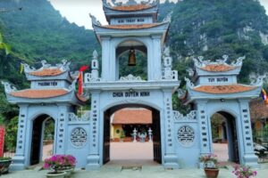
The mountain sits directly behind Mua Cave, and visitors access it through the same entrance gate. There is no separate ticket — entry to Hang Mua automatically includes Ngoa Long Mountain.
 For full location details and directions, see the main guide: Mua Cave Ninh Binh

Relationship Between Ngoa Long Mountain and Mua Cave
Ngoa Long Mountain is often mentioned independently, but in reality, it is the mountain you climb when visiting Mua Cave.
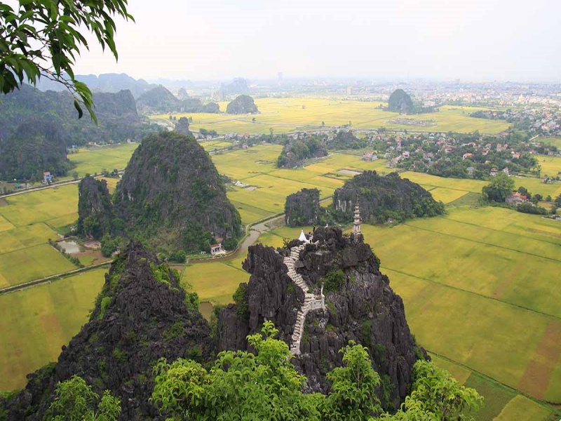
- The famous stone steps at Hang Mua are built along Ngoa Long Mountain
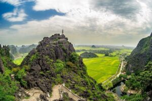
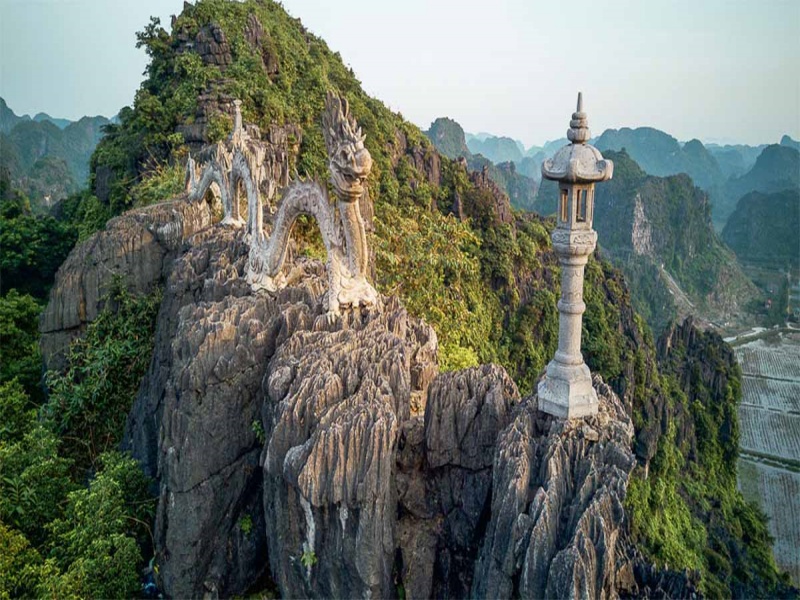
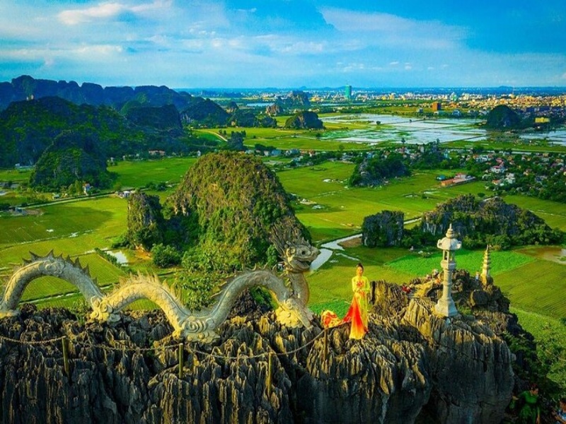
- The iconic dragon statue sits on the mountain’s ridge
- All panoramic viewpoints of Tam Coc originate from this mountain
For this reason, most travelers experience Ngoa Long Mountain as part of their Mua Cave visit, rather than as a separate destination.

What Makes Ngoa Long Mountain Special?
A natural viewpoint over Tam Coc
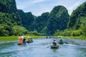
From the upper ridges of Ngoa Long Mountain, visitors can admire sweeping views of Tam Coc’s rice fields, the Ngo Dong River, and surrounding limestone karsts. The scenery changes dramatically with the seasons, from lush green to golden yellow.
Symbolic “Lying Dragon” formation
The dragon-like silhouette of the mountain has strong cultural symbolism in Vietnamese geomancy, representing protection, balance, and prosperity.
A sense of elevation and scale
Compared to ground-level attractions, Ngoa Long Mountain Ninh Binh offers a rare elevated perspective that helps travelers understand the geography of Tam Coc and Trang An from above.
Hiking Experience on Ngoa Long Mountain
The hike on Ngoa Long Mountain consists of stone steps built into the limestone slope. While the path is not long, it is steep in sections and requires reasonable fitness.
- Estimated climbing time: 30–45 minutes
- Terrain: uneven stone steps, exposed ridges
- Difficulty: moderate
Most visitors complete the hike as part of their Mua Cave itinerary.
Best Time to Experience Ngoa Long Mountain
The landscape surrounding Ngoa Long Mountain is most visually impressive during the rice harvest season (mid-May to early June), when Tam Coc’s fields turn golden.
Other pleasant periods include:
- March–April: mild temperatures, fresh greenery
- October–December: quieter atmosphere and clear views
Seasonal details are explained in depth here: Best time to visit Ninh Binh
Tips for Visiting Ngoa Long Mountain
- Wear shoes with good grip
- Bring water and sun protection
- Avoid climbing during heavy rain
- Move carefully along ridges and steps
- Take breaks to enjoy the scenery rather than rushing
Nearby Attractions to Combine
Since Ngoa Long Mountain is part of the Hang Mua area, it’s easy to combine with nearby highlights such as:
See the full list here: Things to do in Ninh Binh

Is Ngoa Long Mountain Worth Visiting?
If you plan to visit Mua Cave, then Ngoa Long Mountain is unavoidable — and unforgettable. While it doesn’t need to be treated as a separate attraction, understanding its role enhances your appreciation of the landscape and explains why Mua Cave’s viewpoint is so iconic.
For first-time visitors to Ninh Binh, Ngoa Long Mountain provides the geographical and visual context that ties together Tam Coc, Hang Mua, and the surrounding karst valley.